DRONE SERVICES & PRICING
We have several popular aerial photography options available as a guide for prospective clients, however if you are looking for something different to the pricing choices below, just get in touch and we'd be happy to provide you with a personalised quote.
The majority of our imagery is shot in oblique (side on), although we are also able to provide vertical orthomosaic (top down) mapping coverage as a great alternative to out of date, lower resolution satellite imagery.
DRONE SERVICES & PRICING
We have several popular aerial photography options available as a guide for prospective clients, however if you are looking for something different to the pricing choices below, just get in touch and we'd be happy to provide you with a personalised quote.
The majority of our imagery is shot in oblique (side on), although we are also able to provide vertical orthomosaic (top down) photographic mapping coverage as a great alternative to out of date, lower resolution satellite imagery.
PREMIUM
A short web ready promotional fly over video set to royalty free backing music
Delivered online or via courier on USB stick
Our all inclusive half day call out rate
$995 +GST
STANDARD
20 high resolution aerial photographs plus
1 birds eye vertical shot of your site
Post Processed for a professional finish
Delivered online within 48 hours
Boundary lines digitally overlaid if required
$595 +GST
BASIC
Post Processed for a professional finish
Delivered online within 48 hours
Perfect for typical suburban sites
$395 +GST
10 high resolution aerial photographs captured from a variety of heights & angles
A minimum of 20 high resolution professionally post processed aerial photographs


We can also supply professional ground level wide angle flash-lit DSLR photography if you require complete indoor & outdoor coverage of your property. Additional fees apply.
Our rates above include 1 - 2 hours on location plus travel to & from the site, although additional charges may apply for travel outside of our primary coverage area. (See map)
Certain sites near by airports may require an additional crew member to be present to comply with CAA regulations and will be priced accordingly.
AERIAL SURVEY
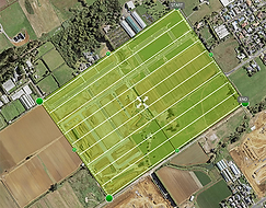
Sky View Photography have the ability to capture high resolution photographic maps of areas ranging from several acres to several square kilometers in size, regardless of the boundary shape.
Sites that would take multiple days to assess using ground based traditional surveying methods can be covered in just mere hours with our drones. Utalising preprogramed grid pattern flight paths, we can acquire up to date high resolution visual spectrum data to a similar accuracy, without disrupting any activity at surface level.
The resulting georeferenced imagery can be output in multiple formats, with accompanying GIS measurements and easily viewable in software interfaces such as Google Earth.

OTHER APPLICATIONS
Aside from the above options, our flying tripod can provide unique and interesting vantage points for almost any other outdoor location that you can think of.
We are happy to provide tailored aerial photography and videography packages for all of the following:
-
Construction site progress overviews
-
Roofing and structural inspections
-
Vineyard and large scale farmland coverage
-
Agricultural crop and stock analysis
-
Safe remote inspection of storm, fire, and earthquake damage
-
Tourism service and accommodation provider promotion
-
Commercial, corporate and industrial premises marketing
-
Elevated 360° viewpoint architectural visualisations
-
Concert, wedding and special event coverage
-
School, College & University campus and group photography
-
Golf Course 'hole by hole' advertisements
-
Cliff and coastal erosion monitoring
-
Half day/full day drone and operator hire
-
Scenic aerial panoramas by commission


DRONE PILOT TRAINING & EXAMINING
Andrew from Sky View Photography holds a CAA Part 141 RPAS Examiners Certificate. This allows him to conduct both theory and practical drone pilot training as well as Part 102 Operational Competency Assessments through Flight Test New Zealand for other drone pilots seeking to gain the qualifications necessary to operate professionally.
Contact us for more information or visit the DroneTrust website to see which of the online courses you can enroll in.
DRONE BUSINESS CONSULTING
If you are considering adding drone technology to your own business, but don’t know where to start- we can help! Andrew can offer one on one consultation sessions, either over Zoom or in person, to help you understand the world of drones. Subjects we cover include the New Zealand regulatory environment, industry best practices, standard operating procedures, hazard assessment and mitigation, unlocking the DJI GEO System, the advantages and disadvantages of Part 102 certification, along with equipment and software advice.
WEATHER CONSIDERATIONS
Flight of our drone equipment is restricted by meteorological conditions such as wind speed and precipitation. Our crew have access to in depth weather forecast systems and will schedule each photography session to cause the least amount of inconvenience, adjusting the time and date as necessary for continued safe operation and best visual results.
As a rough guide for local work, this WINDY forecast covers Auckland for the next three days:

